

Description
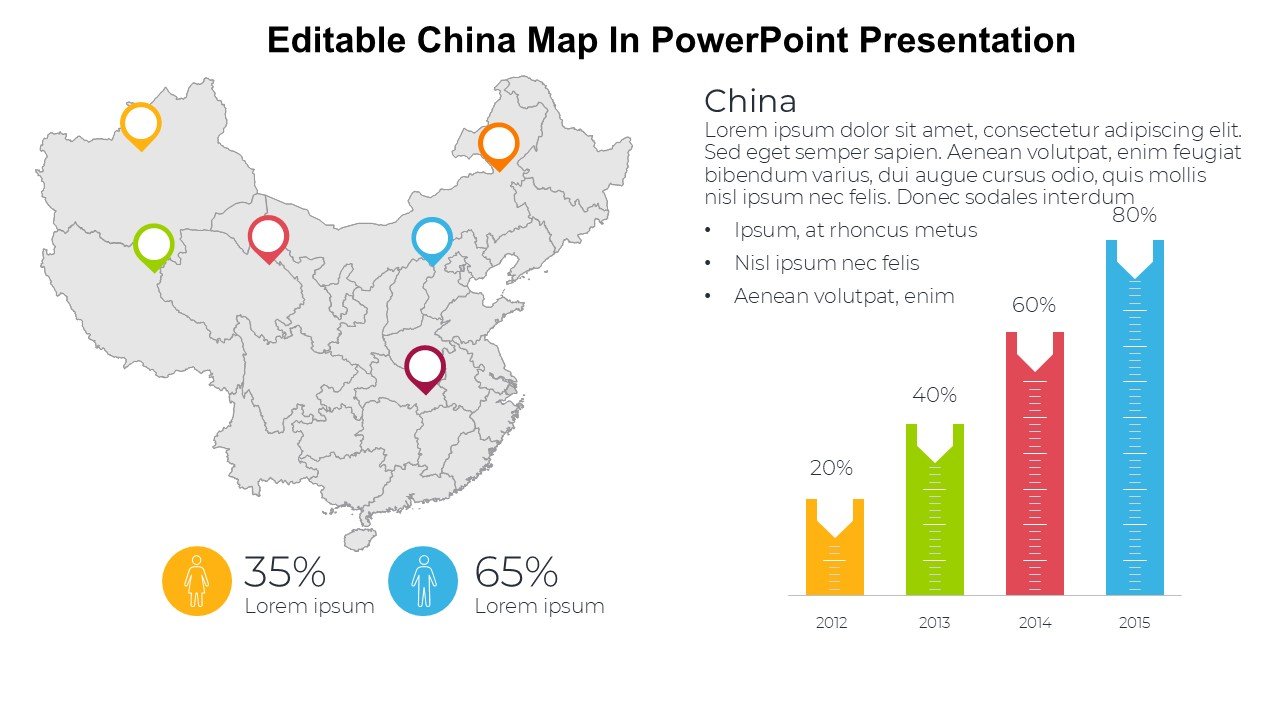
Unlock the potential of your presentations with the Editable China Map In PowerPoint Presentation PPT template, designed to cater to educators, business professionals, and advocates who need a reliable and informative geographic resource. This comprehensive slide template incorporates a detailed map of China, which is fully customizable to suit various educational, commercial, and informational purposes.
The Editable China Map In PowerPoint Presentation slide template is an essential PPT template for anyone looking to present data, research, or insights related to China. Its versatility makes it perfect for academic settings, business meetings, or advocacy groups who aim to discuss demographics, economic data, environmental issues, or cultural studies pertaining to this significant Asian country.
The template’s design is professional and user-friendly, allowing you to modify colors, regions, and markers directly within PowerPoint. Each province can be individually adjusted to highlight specific areas or to showcase regional statistics or developments. Whether you’re a teacher explaining the diverse cultural landscapes of China, a business analyst presenting market research, or an advocate outlining human rights conditions, this presentation template ensures your audience receives a clear and impactful visual experience.
Furthermore, the Editable China Map In PowerPoint Presentation PPT slide facilitates a seamless integration of textual content and data displays. This feature is crucial for delivering presentations that require a balance of visual and textual information. The slide layout is thoughtfully designed to support the addition of legends, notes, and data points, making your presentation both informative and engaging.
Empower your communication with a tool that not only conveys your message but also enhances your presentation aesthetics and effectiveness. The Editable China Map In PowerPoint Presentation is more than just a PPT slide; it is a gateway to exploring and presenting the dynamic facets of China.
Features:
– Fully editable map regions: Customize individual provinces to highlight specific data or areas of interest.
– Easy color changes: Adapt the color scheme to fit your presentation style or corporate branding.
– Insertable data points: Add figures, statistics, and notes directly on the map for a comprehensive view.
– High-resolution graphics: Ensures that the map remains sharp and clear when projected or displayed on large screens.
– Wide compatibility: Works seamlessly with all versions of Microsoft PowerPoint and is adaptable for Google Slides.
Use Cases:
– Ideal for educators teaching Chinese geography, history, or social studies.
– Suitable for business analysts and corporations presenting market analysis or expansion plans into China.
– Useful for NGOs and advocates presenting reports on regional developments or humanitarian efforts in China.
– Perfect for governmental and diplomatic presentations that discuss international relations or trade agreements with China.
– Appropriate for travel and tourism presentations showcasing destinations or cultural heritage across China.

There are no reviews yet.