

Description
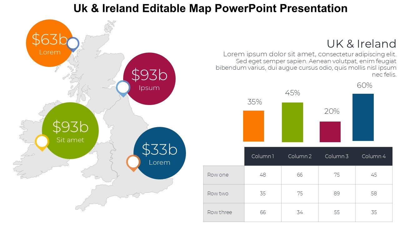
The Uk & Ireland Editable Map PowerPoint Presentation PPT template is a comprehensive slide template designed to cater to the diverse needs of educators, professionals, and advocates who require detailed and customizable maps of the UK and Ireland. This versatile presentation template offers a detailed geographical outline, allowing users to tailor every aspect of the map to suit specific presentation needs.
This PPT slide template is meticulously crafted to ensure it serves a wide array of applications, from educational settings to business meetings. Whether you are a teacher looking to illustrate regional demographics and history, a business professional presenting market analysis or expansion plans, or an advocate raising awareness about regional issues, the Uk & Ireland Editable Map PowerPoint Presentation PPT template provides the tools you need to create impactful, informative, and visually appealing presentations.
The template includes a variety of slide layouts featuring the maps of the United Kingdom and Ireland, which are fully editable and can be customized to highlight particular areas, regions, or data points. The high-quality graphics ensure that even the finest details are visible and editable, making it a perfect fit for detailed cartographic work. Each element of the map can be adjusted—colors can be changed, text can be added or edited, and icons can be placed to denote specific landmarks or data.
Using this PPT template, presenters can easily insert these maps into their existing presentations or build new presentations around them. The Uk & Ireland Editable Map PowerPoint Presentation slide template is not only a functional tool for data presentation but also enhances the aesthetic appeal of your slides, making your data not only more accessible but also more engaging for your audience.
Features:
– Fully editable templates: Customize every element of the slides with ease.
– High-quality graphics: Ensures clarity and detail in presentations.
– Multiple slide layouts: Offers various map views and data representation options.
– Easy to use: Simple for beginners and professionals alike.
– Compatible with PowerPoint: Seamless integration into your current presentation software.
Use Cases:
– Educational tool for teaching UK and Ireland geography, history, or social studies.
– Business presentations for market analysis, expansion strategies, or regional reports.
– Advocacy and non-profit presentations focusing on environmental, economic, or social issues in the UK and Ireland.
– Travel and tourism presentations showcasing destinations, routes, and attractions.
– Real estate presentations to outline regional properties, developments, or market trends.
There are no reviews yet.