

Description
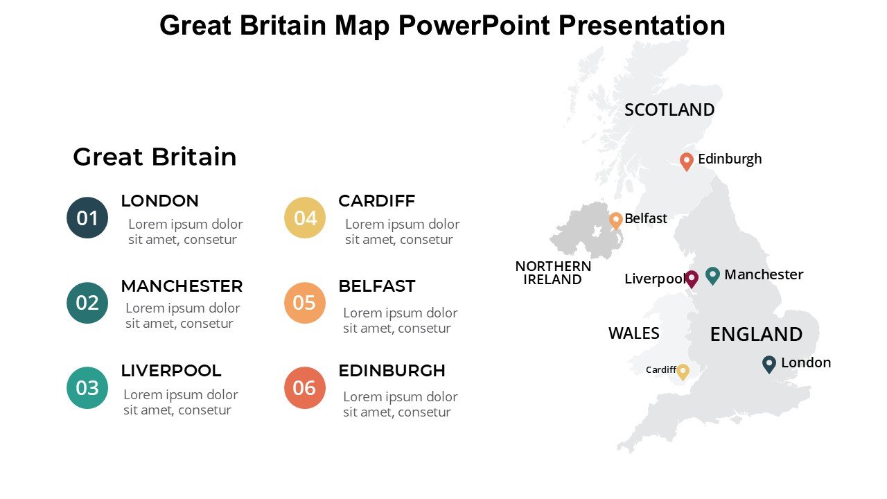
Introducing the Great Britain Map PowerPoint Presentation PPT template, a meticulously crafted slide template designed to enhance your presentations with detailed, high-quality maps of Great Britain. This PPT template is an essential resource for educators, business professionals, and advocates who require an accurate geographical representation of Great Britain in their presentations.
The Great Britain Map PowerPoint Presentation slide template includes a variety of slide designs featuring the complete map of Great Britain, as well as breakdowns into specific regions, cities, and notable landmarks. Each slide is built to be user-friendly and fully customizable to suit a wide range of needs and presentation styles. Whether you’re teaching British geography, illustrating market regions for business strategies, or showcasing travel destinations, this presentation template offers the tools you need to do it effectively and with visual appeal.
Crafted with precision, the slides include scalable vector graphics ensuring that your maps remain sharp and engaging even when edited or resized. The color schemes are thoughtfully selected to enhance readability and aesthetic appeal but can be adjusted to match your specific brand or presentation theme. Additionally, the Great Britain Map PowerPoint Presentation PPT template is compatible with both PowerPoint and Google Slides, making it versatile across different platforms.
For educators discussing UK geography, professionals presenting demographic statistics, or even tourism advocates outlining travel itineraries, the Great Britain Map PowerPoint Presentation slide template serves as an invaluable asset. It not only boosts the visual impact of your presentations but also enhances the audience’s understanding through clear, concise, and engaging map visuals.
Features:
– Fully editable templates: Customize every element of the slides with ease.
– High-quality vector graphics: Ensures sharp and clear visuals at any scale.
– Compatible with PowerPoint and Google Slides: Works across popular presentation platforms.
– Various map breakdowns: Includes whole country, regions, major cities, and landmarks.
– Customizable color schemes: Easily adjust the colors to fit your presentation theme.
Use Cases:
– Ideal for educators teaching British geography or history.
– Suitable for business presentations highlighting market regions or demographics in Great Britain.
– Useful for travel and tourism presentations detailing routes, destinations, or points of interest.
– Valuable for advocates and NGOs presenting data related to environmental, social, or economic issues in specific regions of Great Britain.

There are no reviews yet.